|
|
Weather Alert |
| Prince Edward County, VA | |||||||||
|
|
||||||||
|
Canceled 3/16/26 8:00 PM Severe Thunderstorm Warning issued March 16 at 7:40PM EDT until March 16 at 8:30PM EDT by NWS Wakefield VA SVRAKQ The National Weather Service in Wakefield has issued a * Severe Thunderstorm Warning for... Northwestern Northampton County in northeastern North Carolina... Southeastern Louisa County in central Virginia... Greensville County in southeastern Virginia... Cumberland County in central Virginia... Nottoway County in south central Virginia... Goochland County in central Virginia... Northwestern Hanover County in central Virginia... Southwestern Sussex County in southeastern Virginia... Dinwiddie County in south central Virginia... Powhatan County in central Virginia... Chesterfield County in central Virginia... Southeastern Mecklenburg County in south central Virginia... East central Prince Edward County in central Virginia... Eastern Lunenburg County in south central Virginia... The City of Emporia in southeastern Virginia... Northwestern Henrico County in central Virginia... Amelia County in central Virginia... Brunswick County in south central Virginia... * Until 830 PM EDT. * At 739 PM EDT, severe thunderstorms were located along a line extending from near Gold Hill to near Kenbridge to near La Crosse to near Norlina, moving northeast at 50 mph. HAZARD...60 mph wind gusts. SOURCE...Radar indicated. IMPACT...Expect damage to trees and powerlines. * Severe thunderstorms will be near... Cumberland, South Hill, Blackstone, Crewe, Kenbridge, Brodnax, Nottoway, La Crosse, Dundas, and Sunnyside around 745 PM EDT. Cartersville, Morven, Duncan, Ballsville, Fort Barfoot, Tobaccoville, and Trenholm around 750 PM EDT. Lawrenceville, Amelia Courthouse, Brunswick, Alberta, Spainville, Gasburg, Macon, and Fife around 755 PM EDT. Powhatan, Mannboro, Scotts Fork, Wilsons, and Chula around 800 PM EDT. Goochland, McKenney, and Gum Spring around 805 PM EDT. Moseley, Oilville, and Dewitt around 810 PM EDT. Dinwiddie, Purdy, Radium, Manakin, and Sabot around 815 PM EDT. Tuckahoe, Bon Air, Montpelier, Wyndham, and Sutherland around 820 PM EDT. Other locations impacted by these severe thunderstorms include Bacons Fork, Angola, Gum Forks, Dolphin, Murdocks, Maidens, Henrico, Forksville, Pocahontas State Park, and Skinquarter. 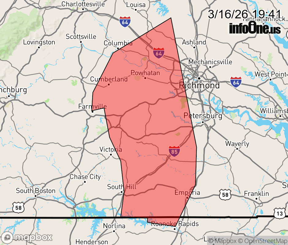 |
|||||||||
 Why aren't you using the InfoOne app? Why aren't you using the InfoOne app?
Stay abreast of information affecting your community! InfoOne tracks real-time information such as:
InfoOne currently supports over 100 communities in NC, VA and WV, and our coverage area is steadily growing. It's free! Install the InfoOne app today and see what you've been missing. |
|||||||||