|
|
Weather Alert |
| Ohio County, WV | |||||||||
|
|
||||||||
|
Canceled 4/14/24 1:58 AM Flood Warning issued April 13 at 4:16PM EDT until April 15 at 1:34AM EDT by NWS Pittsburgh PA ...The Flood Warning is extended for the following rivers in West Virginia...Ohio... Ohio River At Wellsburg affecting Brooke and Jefferson OH Counties. Ohio River At Pike Island affecting Belmont, Ohio and Jefferson OH Counties. Ohio River At Powhatan Point affecting Belmont, Monroe and Marshall Counties. Ohio River At Wheeling affecting Belmont and Ohio Counties. Ohio River At Moundsville affecting Marshall County. Ohio River At Hannibal affecting Wetzel, Tyler and Monroe Counties. ...The Flood Warning is cancelled for the following rivers in Ohio... West Virginia... Ohio River At Wellsville affecting Columbiana County. Ohio River Near New Cumberland affecting Hancock and Jefferson OH Counties. Ohio River At Steubenville affecting Brooke and Jefferson OH Counties. * WHAT... Minor flooding is occurring and minor flooding is forecast. * WHERE... Ohio River at Wheeling. * WHEN... Until early Monday morning. * IMPACTS... At 34.0 feet, Sewers begin to back up in the lower end of Wheeling Island. At 36.0 feet, Flooding begins in the vicinity or 25th and Market Streets, 34th and Market Streets, 36th and Chapline Streets in Wheeling. Water covers the lower parking lot at the Wheeling Island Casino. At 36.6 feet, Wheeling Downs Racetrack on Wheeling Island floods. At 37.7 feet, Basement flooding begins in businesses along Main Street. At 38.0 feet, Portions of Jacob and Wood Streets, south of 43rd Street begin to flood. Wheeling island Casino has to be closed. At 39.0 feet, The southern tip of Wheeling Island including Wheeling Downs Racetrack and Gaming and Wheeling Stadium are flooded. At 40.0 feet, Backwater flooding begins to affect Main Street near the water treatment plant in Wheeling. * ADDITIONAL DETAILS... - At 3:30 PM EDT Saturday the stage was 37.7 feet. - Bankfull stage is 36.0 feet. - Recent Activity...The maximum river stage in the 24 hours ending at 3:30 PM EDT Saturday was 37.7 feet. - Forecast...The river is expected to rise to a crest of 38.3 feet just after midnight tonight. It will then fall below flood stage tomorrow evening. - Flood stage is 36.0 feet. - Flood History...This crest compares to a previous crest of 38.3 feet on 03/10/1956. - http://www.weather.gov/safety/flood 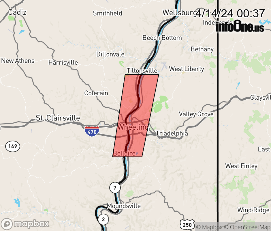 |
|||||||||
 Why aren't you using the InfoOne app? Why aren't you using the InfoOne app?
Stay abreast of information affecting your community! InfoOne tracks real-time information such as:
InfoOne currently supports over 100 communities in NC, VA and WV, and our coverage area is steadily growing. It's free! Install the InfoOne app today and see what you've been missing. |
|||||||||