|
|
Weather Alert |
| Gaston County, NC | |||||||||
|
|
||||||||
|
Canceled 7/9/25 10:35 PM Flood Advisory issued July 9 at 8:17PM EDT until July 9 at 11:00PM EDT by NWS Greenville-Spartanburg SC * WHAT... Flooding caused by excessive rainfall is expected. * WHERE... A portion of piedmont North Carolina, including the following counties, Cleveland, Gaston and Lincoln. * WHEN... Until 1100 PM EDT. * IMPACTS... Nuisance to Minor flooding of low-lying areas adjacent to streams and other poor-drainage areas, including farmland, parks, greenways, boat-access areas, golf courses, underpasses, and parking lots. Isolated, shallow flows over roadways is possible. A few flood-prone, low-water crossings may become impassible. A small culvert washout or two is possible. * ADDITIONAL DETAILS... - At 802 PM EDT, Doppler radar and automated rain gauges indicated heavy rain is ongoing due to multiple slow-moving thunderstorm cells extending west to east to northeast from Lawndale to Fallston, Cherryville, Lincolnton, and Boger City. Between 1 and 2.5 inches of rain has fallen over the past 45-75 minutes. These cells are training from west to east over the same areas, prompting concerns for excessive runoff capable of producing areas of nuisance to Minor flooding. Areas of greatest concern include in the Lincolnton, Boger City, and Goodsonville areas, where rainfall accumulations of 2 inches in 30-45 minutes will be enough to overwhelm low- lying areas, small drainages, and stormdrains, causing ponding of farmland, woodland, residential yards, golf courses, and a few roadways. Concern includes small streams near Huss St, Walker Branch near N Aspen St and N Flint St, Lithia Inn Branch near Jerry Crump Rd and Jonas Dr. Clarks Creek near Clarks Creek Rd and Jeb Seagle Dr may also rise out of its banks. In Cleveland County, small streams near Fallston and Lawndale, including Grassy Branch near Hicks Hill Rd, Knob Creek near Brackett Rd, and Flag Branch near Union Church Rd may cause flooding. - An additional 1-2 inches of rain is possible over the next 60 minutes due to these very slow-moving cells. This rainfall may exacerbate developing flooding or cause new areas of flooding to develop. If these cells persist for an additional 60 minutes or longer, a Flash Flood Warning may be issued. Caution is advised near any stream or other vulnerable area. Seek higher ground immediately if streams start to rise. Please have a plan in place should flash flooding develop and do not hesitate to act. - Some locations that may experience nuisance to Minor flooding include... Shelby, Lincolnton, Cherryville, Belwood, High Shoals, Lawndale, Fallston, Polkville, Waco, Kingstown, Boger City, Iron Station, and Crouse. - http://www.weather.gov/safety/flood 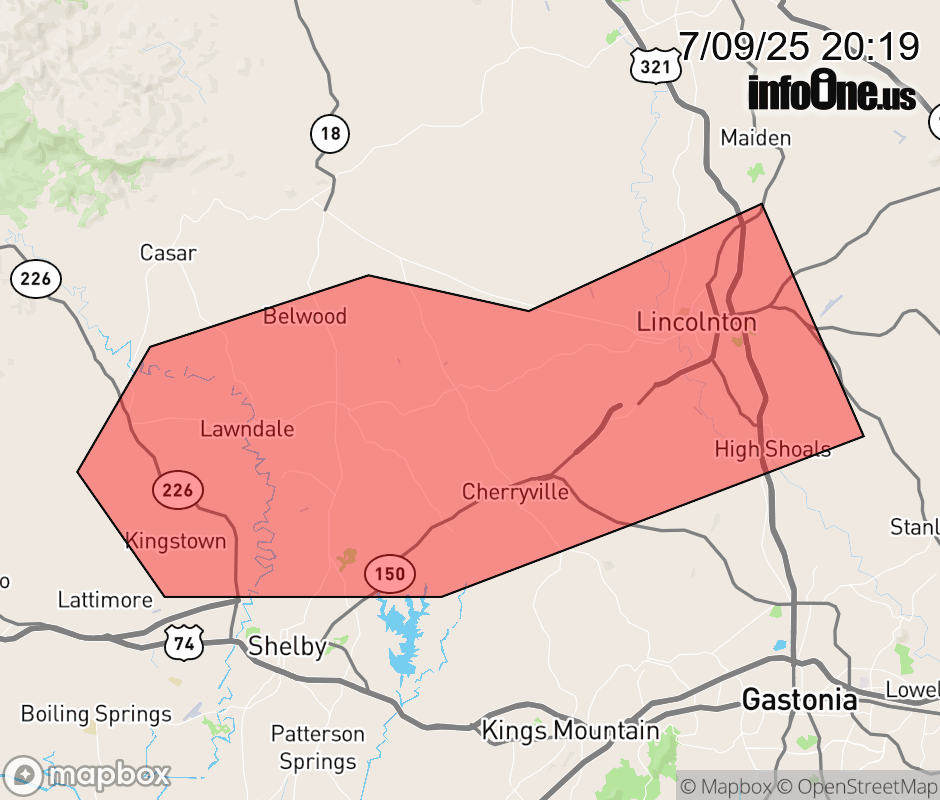 |
|||||||||
 Why aren't you using the InfoOne app? Why aren't you using the InfoOne app?
Stay abreast of information affecting your community! InfoOne tracks real-time information such as:
InfoOne currently supports over 100 communities in NC, VA and WV, and our coverage area is steadily growing. It's free! Install the InfoOne app today and see what you've been missing. |
|||||||||